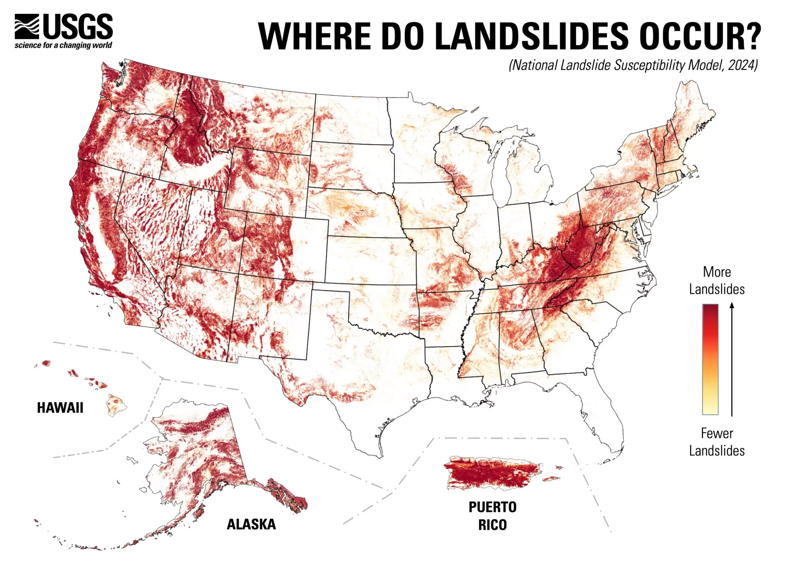
The U.S. Geological Survey (USGS) has unveiled a groundbreaking landslide susceptibility map that highlights a staggering statistic: nearly 44% of the United States is at risk of experiencing landslide activity. This detailed county-by-county analysis serves not only as a warning but as a crucial resource for planners, engineers, and emergency responders. The innovative mapping endeavors to depict areas prone to damaging landslides and those that remain comparatively safe, guiding risk management strategies and land-use planning efforts across the nation.
The launch of this map signifies a substantial advancement in geographic understanding of landslide hazards. The research conducted by USGS focuses on a significant but often overlooked issue—how to effectively identify locations at heightened risk of landslide activity. It succeeds in presenting a comprehensive view of susceptibility across diverse terrains and climates, revealing the intricacies of geological hazards that affect communities nationwide.
Innovation in Research Methodology
What sets this new assessment apart from previous landslide mapping efforts is its extensive use of technology and data. Prior to this initiative, high-resolution landslide maps primarily existed for select regions known for their geological instability. The USGS team, led by geologist Ben Mirus, has employed sophisticated computational techniques to merge an inventory of almost one million historical landslides with cutting-edge elevation data derived from the USGS 3D Elevation Program.
This meticulous approach has crafted a finely detailed model showcasing landslide susceptibility across the contiguous United States, Alaska, Hawaii, and Puerto Rico. This upgraded resolution enhances our understanding of landslide tendencies, making it easier to identify specific areas that might not have been previously regarded as risky but are now highlighted as susceptible.
Broader Implications for Land-Use Planning
The implications of this map extend far beyond academia; they touch every corner of society, from urban development to environmental conservation. By providing a detailed overview of potential hazards, local and state agencies can make informed decisions about land-use planning aimed at minimizing risk. The detailed insights will help prioritize mitigation strategies, enabling communities to allocate resources more effectively to safeguard lives and property.
Moreover, the map serves as a critical tool for emergency preparedness. As communities analyze their potential vulnerabilities, they can develop response plans that consider not just known hazards but also those newly identified by the map. This information empowers residents and local authorities to adopt safety measures and enhance the overall hazard readiness of their jurisdictions.
The USGS’s new landslide susceptibility map is vital for enhancing national understanding of geological hazards. With nearly half of the country potentially at risk, proactive identification and mitigation of landslide threats become essential components of risk management strategies. This initiative represents a significant step toward creating a more hazard-ready nation, ultimately aiming to protect lives and infrastructure through informed planning and community readiness.

