Nitrogen dioxide (NO2) often goes unnoticed, lurking in the atmosphere as a byproduct of our industrial activities and daily lives. Emerging primarily from vehicle exhaust, power plants, and even natural occurrences like lightning, this pollutant is a double-edged sword. While we depend on the energy produced by fossil fuels, the repercussions of NO2 emissions are grave. It contributes to air quality deterioration, significantly affecting human health and the environment by exacerbating respiratory conditions and promoting the formation of smog. Whether it’s the brownish haze we see enveloping urban landscapes or the hidden consequences on sensitive ecosystems, nitrogen dioxide plays a critical role in our ongoing battle against air pollution.
Traditionally, satellite monitoring of nitrogen dioxide has not achieved the desired granularity—often providing broad strokes that overlook specific pollution sources like power plants. However, a game-changing study published in the Proceedings of the National Academy of Sciences has revealed a groundbreaking application for the Copernicus Sentinel-2 and U.S. Landsat satellites. Utilizing sophisticated imaging techniques, researchers have been able to visualize NO2 plumes emanating from individual power plants for the first time. This represents a seismic shift in our ability to monitor air pollutants, offering a clearer window into the sources of NO2 emissions and their broader environmental implications.
This innovative accomplishment stems from Sentinel-2’s detailed spatial resolution, which has primarily been targeted toward land cover, vegetation, and water monitoring. Yet, its adaptability has allowed it to capture atmospheric phenomena, including nitrogen dioxide plumes. This development could fundamentally alter how we assess air pollution—moving from generalized models to localized analysis that pinpoints emission sources with astounding accuracy.
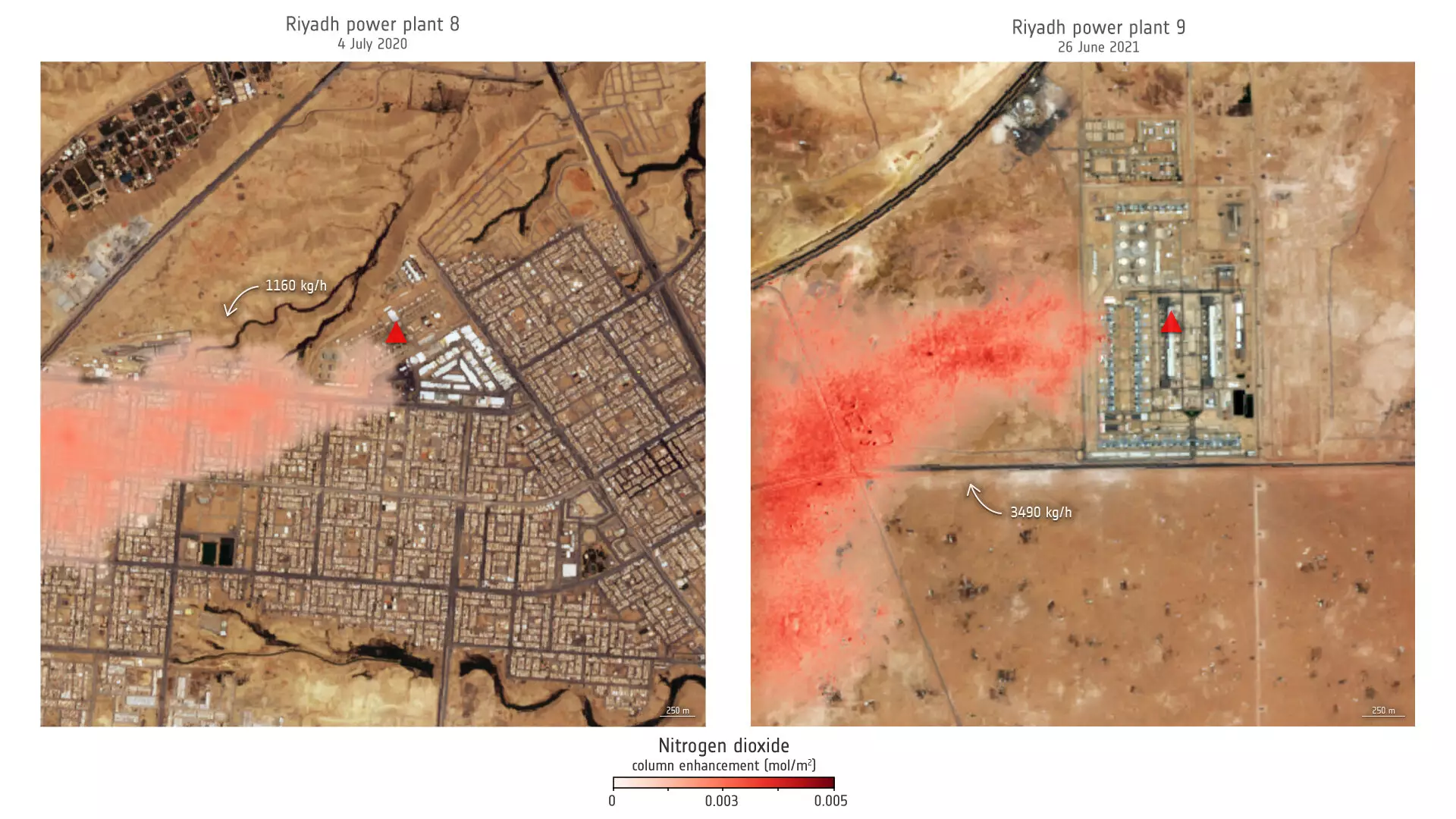
Focusing on power plants in regions as diverse as Saudi Arabia and the United States, researchers employed satellite imagery to gauge nitrogen dioxide emissions. They assessed significant players such as Riyadh Power Plant 9 and another facility in Wyoming, unveiling unprecedented insights into emission trends over the years. For instance, data analyzed over a 13-year period revealed striking seasonal changes in NO2 output, with summer months driving emissions higher due to increased air conditioning demands.
This nuanced understanding is pivotal, allowing stakeholders to craft more informed strategies to combat air pollution. It also reinforces the necessity of monitoring in urban areas, where the proximity of multiple pollution sources complicates traditional measurement efforts. As lead researcher Daniel Varon noted, this newfound capability shines light on pollution sources in dense urban settings, enabling both researchers and policymakers to focus their efforts where they are needed most.
Despite the advantages offered by satellite data, challenges remain. Varon highlights that satellite effectiveness can wane over complex terrains or darker surfaces. This could potentially limit the reach of nitrogen dioxide detection in certain urban environments. Nevertheless, the value of these high-resolution imaging techniques cannot be overstated. They provide an essential tool in our increasing arsenal against air pollution, allowing for precision monitoring even in less-than-ideal scenarios.
Moreover, the ongoing improvements in satellite technology, such as the forthcoming Sentinel-2C, promise to enhance our monitoring capabilities. Scheduled for launch in 2024, this satellite will continue the legacy of its predecessors by providing continuous imaging across numerous spectral bands, offering an expansive scope for environmental monitoring initiatives. This evolution highlights humanity’s capacity for innovation, even in the face of pressing ecological challenges.
The amalgamation of high-resolution satellite imagery with ground-level observations presents governments and organizations with a compelling opportunity to tackle air pollution. With the capability to identify and monitor nitrogen dioxide emissions at a granular level, it empowers decision-makers to devise targeted interventions. Understanding emissions patterns allows for precise implementations, whether that involves incentivizing shifts toward renewable energy, enhancing public transport systems, or setting stricter regulations on industrial emissions.
As we stand at the juncture of data accessibility and environmental responsibility, the task ahead is not merely to observe but to act. The challenge is not only to leverage these technological advancements but to integrate them into the fabric of policy-making aimed at safeguarding public health and ensuring clean air for future generations. By fostering collaboration among researchers, governments, and the public, we can create resilient strategies that not only mitigate the impacts of nitrogen dioxide but also pave the way for a cleaner, healthier planet.